Sunday, September 26, 2010

The Mighty Thelon


July 22- July 25
After our first full day on the Thelon River we had completed 187 kilometres, with 185 left to do. We were half way to our destination at Warden's Grove with 8 days left to our scheduled date of pick up. We had taken 10 days to get here, and we had to work very hard to make the progress we did. We were all concerned that if we encountered more difficult terrain, or if we ran into bad weather we would not make our destination in time.

Our fears were allayed to a large extent by the fact that over the next few days we made very good progress and the weather remained quite fair. In fact, over the next few days we travelled 133 kms., averaging 44 kms. per day. We managed to catch fish and had a feast of pike or trout each night.

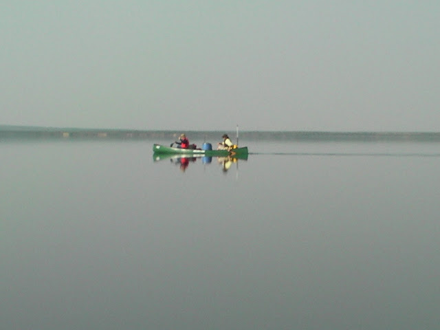
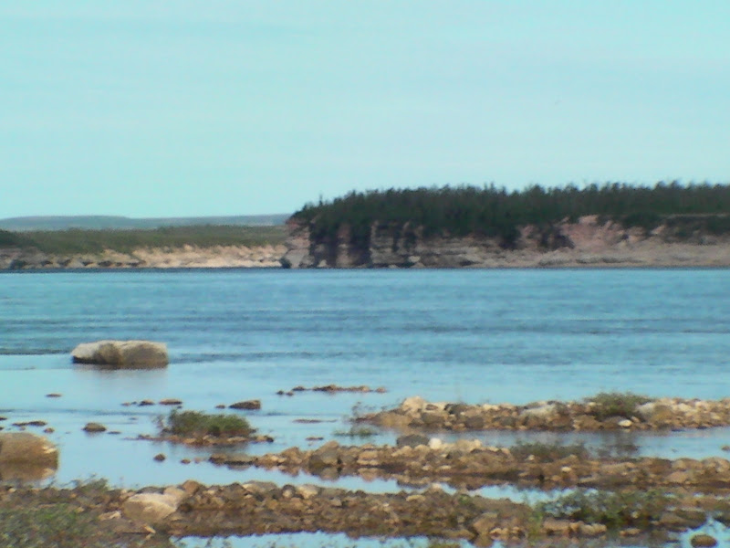
The topography of the river in this section is dominated by sand eskers and sandstone canyons. The river current was very fast, at times the canoe reached speeds of 10-12 km/hr with little or no paddling. The swifts and sandstone ledges became more evident as we approached the delta where the river enters Eyeberry Lake.

Through one of the sections of swifts, where the river entered a shallow canyon, Nestor and Roman were in the lead canoe. Taras and I were about 200 metres behind and I noticed that the horizon fell away in a sharp line. I told Taras to head over to the left shore and instinctively began to draw the canoe in that direction from the bow. It was then that we saw that Nestor and Roman were in trouble as they hit the ledge and began to scramble out of the listing canoe. The two were able to avert disaster by holding onto the canoe and climbing onto a large exposed sandstone boulder in the middle of the river. In the process they broke a paddle and lost another one to the current.

Meanwhile, Taras and I slipped down a set of rapids on the river left. The rapids were tricky but manageable once Taras and I had our communication perfected. I kept yelling, "Draw Left!" Taras and I spotted the lost paddle and were able to retrieve it from the eddy. We talked about watching for signs in the river for differences in elevation that could spell trouble. This was to me a further reminder how little fast water experience my travelling partners had.

Eyeberry Lake and beyond
We entered Eyeberry Lake on the western shore at the north end of the large island in the delta. The cross winds were moderate and made for a difficult paddle, but we managed to reach the end of the lake in two hours. After the lake the river picked up speed as we paddled through canyons of sandstone and shale. We negotiated a set of class II rapids and about 5km of swifts and a little later a set of class II rapids where the river was split by two islands. The left channel was runnable.

At some point in the remaining few days, there was a suggestion that since we were making good time, we might be able to arrange an earlier flight out. The others had young families, so perhaps there was a felt need to cut the trip short by a couple of days. In retrospect, this plan was unreasonable since our flight out was coordinated with an incoming flight carrying another of Tundra Tom's clients. The extra flight would have meant an extra cost for Tom.

The result was that there now seemed to be added pressure to push on. The good travel days we had up to this point on the Thelon added to the anticipation of completing earlier than planned. The weather on July 26, however, slowed our progress tremendously. The north wind was cold and rain threatened throughout the day. Added to this delay, Nestor left his fishing rod on shore at the campsite and only discovered it missing after we had been on the water an hour. This meant a two hour delay while Taras and Roman offered to return to the campsite to retrieve it. Later in the day we were further halted by a storm and a quickening wind. The day eventually cleared but the wind remained strong. We were only able to make 20 km. this day.

The Thelon Canyon
During the final section of the river, toward Warden's Grove, the river picks up speed as it cuts through sandstone canyons. Heeding Tundra Tom's advice we approached a class II set of rapids with a tight left past the bulk of the turbulent water and rocks. A few kilometres down stream from these rapids we approached the Thelon Canyon, a 7 km stretch of ledges and chutes that needed to be portaged and tracked. We chose to portage from the left bank, which I later learned from Rob Kesselring was a mistake. The decision would add misery to our trek that could have been avoided had we chosen the slightly longer, but more even terrain of the right bank.

We estimated our portage to be about 3 km each pass. Given that we had three loads of gear, it would mean that we would have to make three loaded and two unloaded trips, a total of 15 km. At best this would take us six or seven hours. Since we had arrived at 1:30 in the afternoon, I suggested that we take the canoes over in the afternoon, camp overnight at the head of the canyon and trek the last of the gear over in the morning after a good night's sleep. To my surprise and dismay the other three were determined to complete the portage and to continue paddling late into the evening.

Whenever I have travelled with others, there is always an ethic that says that we do not push the trip beyond what any of the members feels they are able to do. I felt at that time, I would be unable to find reserves to complete 7 hours of physical endurance, let alone paddle after the portage. The desire to push on and complete the trip early, however, meant that the three friends were not going to consider my plan to take our time and conserve our energy. No one seemed willing to challenge Nestor's desire to push on.

The portage itself was gruelling. On the second trip over carrying the canoe with Taras, I fell several times as my feet sank into the bog of the tundra. I responded in frustration. The trail was uneven and meandered through bog, up and down sand and stone ridges and through dense bush. We were plagued by black flies, but that was the least of my suffering. By now I had developed a deep and abiding resentment toward my travelling partners, who up to this point had been ideal travelling companions.

Reaching a sandy beach on the right bank we made the decision to make camp. This was in part because we could not see the next set of rapids in the setting sun (the time must have been 10 or 11 at this point). After a quick dinner we took some photos of the full moon above the tents and then retired for the night.

Warden's Grove
With only about 10km left to our destination we learned that we would not be leaving two days early, but rather on our scheduled flight on July 30th. The next morning we ran the last set of rapids and spent some time where the rapids undercut the cliffs on the right bank. There was an eddy here where we went bathing and watching cliff swallows that had built their nests of clay in the sandstone overhang.

We now had a couple of days to spend at Warden's Grove, but unfortunately neither Taras, nor Nestor recognized the spot from their last trip. The place I had marked on my GPS was a place that reminded them of the campsite, but they remained unconvinced and after phoning the air service, we pushed on down the river about 1 km past the coordinates they gave us.

Over the next afternoon Roman and I tried unsuccessfully to locate the Warden's Grove cabin (it must have been about 700 metres up river from where we ended up searching). It was a disappointment to me not to locate the cabin knowing that I may never have another chance to visit this river. I had read Chris Norment's account of his experiences researching the Harris sparrow from the cabin in his book "Return to Warden's Grove" and had hoped to recognize the places he had described so intimately.

My disappointment was allayed to a large extent when Roman and I were alerted by Taras and Nestor over the walkie-talkie that a bull muskox was on the left shore of the river at the point I now believe must have been Warden's Grove. We paddled up river to within 50 metres of this majestic animal feasting on the shore grasses. He was seemingly unconcerned with our presence as we took videos and pictures from the canoes. This was a highlight of the trip.

The last day on the river was spent fishing, relaxing and sorting out gear for the flight home. The memories of this trip would be mixed. There was adventure for sure and the splendour of the tundra was unforgettable. The physical nature of the trip was satisfying in that I came away with a sense that I could still tackle a trip of this nature. I regret that I was not able to feel a closer bond with those I travelled with. None of us expressed a wish to travel again together.

Monday, September 13, 2010

The Elk River: The Rapids


After Damant Lake, the last of the large lakes on the Elk River, the descent off the Precambrian shield begins in earnest. The elevation at Damant Lake is 390 meters above sea level, and where the Elk River enters the Thelon River the elevation is 300 meters. In the 120 km, therefore, from Damant Lake to Granite Falls (where the two rivers meet),the drop in elevation is 90 meters or 295 feet! Forty meters of that drop occurs in the last 5 km. There was some serious white water paddling to be done.

For our group the rapids presented a particular challenge. None of us was prepared for the what lay ahead, least of all my travelling partners, whom as I have already stated had no white water experience. We agreed after the first set of rapids that we would scout everything and that if any one of us felt uneasy about running we would track or portage.

I have provided as good a description of the rapids as I could from my trip journal on the Wilderness Canoe Association website (http://www.myccr.com/canoedb/routeDetails.php?routeid=876). As the route description notes, there were a few days where river travel was quite difficult and we ended up walking the through the safe water close to shore, a technique called tracking. This was difficult for me because I am not the most agile guy around. All of us found these days strenuous given the amount of hiking we did to scout the river, and given the amount of lifting the fully loaded canoes.

The days of tracking were contrasted with days when we were able to paddle 30 or so km with little difficulty through easy rapids and swifts. By about the 9th day, however, we began to worry whether we would be able to make Warden's Grove, the end point of our trip on the Thelon, by August 30th. This created some pressure to push ourselves when we could and we envisioned having to work this hard for every inch of ground even when we reached the Thelon.


The Dump at the Narrows
The Elk started to get tricky very shortly after leaving Damant Lake. The day we left Damant we were successful in running the class I and the swifts and our confidence was given a boost.

On day two things got somewhat trickier. Taras and I were the first to attempt to run a class I+ set of rapids. We had scouted the rapids and had a pretty good idea of how to approach them with a slight shift to the right after which there was an easy draw to the left. All went according to plan for the first 100 meters; I was in the bow and was able to draw right around the first submerged boulder. As is typical of guys who haven't paddled together before in white water, there were communication problems which in very short order created havoc. Before we knew it, the water was pulling us onto an submerged boulder on our right. My attempted correction, - a draw to the left- without Taras working with me, meant that we broadsided the boulder and were dumped into the river for a 400 meter swim through fast current.

We managed to recover our gear, except for Taras' fishing rod and tackle. And after changing into dry clothes we set out again. Needless to say, we were far more cautious with the rest of the rapids and made sure we tied the gear in the canoes, something we had neglected to do up to this point. In looking back on the incident I made a mental note that it is necessary when canoeing with novices to fully review the role of stern and bow paddlers. People who have only done flat water canoeing are under the impression that steering of the canoe is the job of the sternsman. And in flat water this is the case. But in white water the bowsman often sees obstacles well in advance and acts to correct the course; the sternsman then acts to move the canoe sideways in the direction set from the bow.

Unexpected Guests
On the morning of July 20th, as we ate our breakfast, we were hailed from the river by a pair of paddlers. The canoe was well fitted with deck covers and a spray skirt. The canoeists were Rob Kesselring and his friend Peter. Rob and Peter were attempting to complete a 1400 km trip across the subarctic to Baker Lake. They had to end their trip at Beverley Lake - impressive none-the-less.


The Unmarked Rapids, and Then the Falls
The drop in the last 5 km of the Elk River is about 40 meters. The majority of this drop is through Granite Falls. There is, however, about 2 km of class III+ rapids that are not marked on the topo maps. We wisely pulled out of the river upon hearing the roar and chose to portage this set. It is my opinion that Bill Layman really underestimated this set of rapids in his write up and I am doubtful they could be run in an open canoe. Check them out for yourself below.


Granite Falls is really quite a spectacular piece of real estate. I has 8 or more steps and runs over pink and red granite through a narrow gorge. I have included the video of one of the last steps on this blog. After these falls the Elk joins the flow of the mighty Thelon.


Next: The mighty Thelon - river of fish

Tuesday, September 7, 2010

The Upper Elk River: The Big Lakes

The Upper Elk river is characterized by several large lakes, the largest being Vermette, Rennie and Damant. The first day out saw us paddling to the northern end of Rennie, stopping where the lake branches to the west and the east. Traversing the inlets and bays of the large lakes meant that we had to check and re-check our position on the topo maps. I was glad that I had pre-loaded the waypoints into my GPS before setting out, when we were in doubt a simple check was all we needed to stay on course.


Rapids Between the lakes
For the next two days we paddled east through Rennie Lake, picking up the Elk river at the narrows between Rennie Lake and Damant Lake. It was at this point that we encountered our first set of rapids; a set of class I and a few swifts. I learned here that my travel companions had little prior experience with white water. Skills that are needed to run rapids safely include being able to, execute special strokes (draw, pry, ferries etc.), "read" the water and wave action to predict the presence of rocks and execute canoe rescues in fast water. My new canoe mates did not have practice with these skills, or any training through courses. I made a note in my journey that, we would need to be careful through the rest of the fast water that we might encounter. Fortunately, the rapids we had just completed were not technical and we were able to make a successful run with the loaded canoes.

Damant Lake
Damant Lake proved to be more confusing than Rennie, given the abundance of bays and inlets. It took us two days to traverse this large lake and we were quite fortunate not to have encountered much by way of head wind. The weather was warm, mainly clear and only moderately windy. It was very fortunate, indeed, that the wind through Damant was at our back, not only were we pushed along with a 2.5 km/hr boost, but the wind kept the black flies at bay.

On both of the days on Damant Lake Nestor showed off his fishing prowess. By trolling the large lake on the first day he and Taras were able to catch a couple of nice sized lake trout for our dinners. Nestor and I caught arctic greyling on the second afternoon. These we caught in the rapids where the Elk river leaves Damant Lake's north shore.

Bird Life

One of the delights that I appreciated on the large lakes (and throughout the trip) was he abundance of bird life. Birds that we had identified in large numbers up to now included Harris Sparrows, Hooded Mergansers, Lapland Longspurs and Arctic and Common Terns and Thayers Gulls.

On our campsite at the north end of Damant we were treated throughout the evening and next morning to the alarm calls of a pair of nesting Whimbrels (a member of the curlew family).


Whimbrel Video


Next: The Elk River white water. (click to continue)

Sunday, September 5, 2010

Elk and Thelon Rivers: A Brief History


Stony Rapids, Saskatchewan


Northern Saskatchewan has been the traditional home of the Denesuliné (pronounced as Den-a-sooth-leh-na). They have survived in this landscape for millennia by hunting the Beverly Lake caribou that make annual migrations to the north through the Thelon River watershed. Stony Rapids and Black Lake, are two communities where the present day descendants of the so-called Et-en-eldili-dene or "caribou-eaters" now live.

In 1893, the Tyrrell brothers (J. W, and J. B.) travelled through Stony Rapids and Black Lake from the eastern end of Lake Athabasca on their way north and onto the Dubawnt River, a tributary of the Thelon. An excellent account of this expedition can be found at the online book archives as an e-book. In his report to the Canadian government, following the earlier 1890 expedition J. W. Tyrrell recommended that the Thelon basin be "set aside... as a game preserve" to ensure the survival of the muskoxen in the region (Pelly, 1996 pp 28).


The Elk River

I was unable to gather information prior to our trip as to the European history of the Elk River. I was able to find a description of the Bill Layman's trip (undated), but not much else. Layman's description of the rapids was generally accurate, although I think his account underestimates the seriousness of the last set of rapids before Granite Falls. In general, his account did not seem to provide sufficient information by way of a river guide, so I did not think to take it with me. Re-reading it after the trip, I realize that there may have been a couple of places where his account may have been useful.

On the morning of July 13, Nestor, Taras, Roman and I shuttled our gear down to the dock and prepared to board the Twin Otter bound for the upper end of Vermette lake on the short stretch of river that flows into Rennie Lake. In surveying the maps in advance of the trip it was the expanse of open water on the lakes of the upper Elk that caught my attention. Looking at these large lakes, I envisioned being wind bound for long stretches as we negotiated the 60 to 90 km of flat water.

As we touched down on the river, the sand spit made an excellent landing place to unload our gear and prepare for the trip. The day was an omen for the weather we were about to encounter during the rest of our trip; it was bright and warm with a slight haze in the air form the forest fires of Northern Saskatchewan to the south. The black flies were out in large numbers as we set about the task of assembling the canoes that arrived with Tundra Tom on his Cessna 180.

Before we set out Tom gave us a briefing on the indigenous and European history, points of interest along the way, several rapids to watch for on the Thelon River and the general description of the Elk as a "Class III river". It was the last statement that concerned me, given that this was the first time I had heard the Elk river described this way. Layman had referred to the rapids as "easy", Tom was giving a whole new dimension to the nature of the trip on which we were about to embark.

Despite any reservations we may have had, we were eager to get started and so headed in a northerly direction to the a peninsula where the lake swings to the east. It was on this peninsula, where the lake narrows, that we made our first camp. We were in the vicinity where the Denesuliné would camp in family units waiting for the fall caribou migration. And there was ample evidence of past hunts to be seen in the abundance of caribou bones and antlers in the sand eskers.

Next: Travelling on the large lakes; of wind, lake trout, swifts and Class I rapids.

The Elk River: Getting There

Planning and executing a trip into remote areas takes a considerable amount of work to address the logistics of transport, equipment needs, and scheduling. Having completed this work on previous trips, for example the Nahanni River in 2007, I am grateful to Nestor Lewyckyj for his role in arranging the outfitting of canoes and air transport with the "legendary" Tundra Tom. (I have listed a number of recommendations at the end of this blog for those considering this trip concerning logistics).

My travel companions, Nestor Lewyckyj, Taras Gula and Roman Poluha have known each other since childhood and have trekked together on other occasions. One of the dynamics that played out on the trip was my need to adjust to a cohesive group with whom I did not share prior history. That being said, I felt welcomed from the outset and my travelling partners were generally agreeable and easy to get along with. The fact that we had all participated in the scouting movement provided a reference point for the ethics associated with camping and group cooperation.

We had arranged that I meet with the others in Winnipeg on July 10th and from there we would drive the 1800 kilometres to Stony Rapids, Saskatchewan. The guys picked me up at the Winnipeg airport at about noon on the 10th and we arrived at our destination in the mid afternoon of the 11th. It is interesting to note that the original end point for our journey was to be Points North Landing, SK some 200 km. south of Stony Rapids, but due to contractual difficulties between Tundra Tom and Tindi Air our plans were changed at the last minute. Our new carrier was to be Transwest Air. This change meant that we would have to drive an additional 200 km, taking us nearly 7 hours, over an extremely rough road, that a regular sedan would not have survived.

The trip from Winnipeg provided myself and my travel-mates an opportunity to get to know each other. We took turns being driver, co-pilot and backseat sleepers as we drove continuously for the thirty-something hours. This road trip became an adventure in its own right as we witnessed changes in the terrain, wildlife sightings and a forest fire in progress. The road trip was, in fact, a continuation of a much longer journey that Nestor, Taras and Roman had begun in Montreal on July 8th. Needless to say, we were all glad to have arrived at the Whitewater Inn and receive the hospitality of our hosts, Tim and Pearl.

Once we were settled in at the Whitewater Inn we learned that our flight onto the Elk River would be delayed a day due to unforeseen damage to the pontoon of the Twin Otter that would carry us. While somewhat concerning, given that it would mean one less day on the river, this delay allowed us to organize our gear and to rest after the road trip. We took the opportunity to explore the waterfront at Stony Rapids and take in the local scene. Given that Stony Rapids and the neighbouring community of Black Lake are dry and the fact that we had failed to buy beer or wine en route, were consigned to drinking Roman's whiskey in our rooms!

For access to my still pictures of the trip visit Elk River And Thelon Rivers pictures.


Recommendations Re: logistics
  • Points North and Stony Rapids are excellent locations from which to launch your expedition into this region of the Northwest Territories, as they are served by an excellent air carrier in Transwest Air
  • The difficulty in road travel to Stony Rapids can be avoided by taking a Transwest flight from Saskatoon, SK to Points North, SK
  • Churchill River Canoe Outfitters can provide canoes and gear out of both Points North and Stony Rapids


Next: Brief History and the Trip begins
(click to continue)